Frequently Asked Questions
Who oversees the North Kansas City Levee District?
A five-member Board of Supervisors governs the North Kansas City Levee District. Board members must own property within the protected area and are
elected by the landowners for 5 years. This practice helps to ensure that the levee system is maintained to high standards. With only landowners eligible
to serve on the Board, the decision-makers are vested in how the levee system is operated and maintained. Every person on the Board has the same concerns about flooding as you do.
What area is protected by the levee?
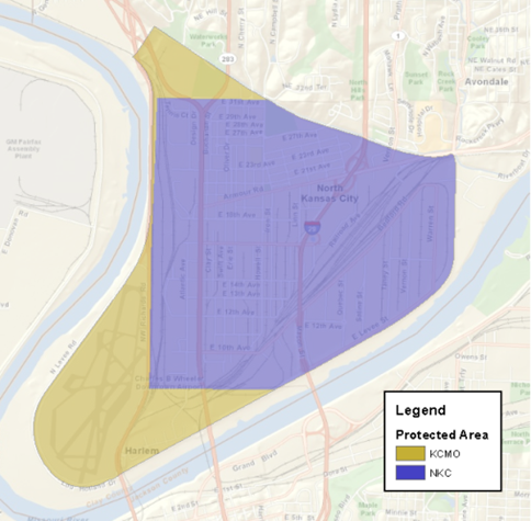 Figure 1 – Protected Area of the North Kansas City Levee Unit
Figure 1 shows the area protected by the North Kansas City Levee Unit. The levee protects about 2,930 acres of land and includes portions of North Kansas City and Kansas City, Missouri.
There are approximately 1,800 properties protected. Of those properties, about 840 are residential. The U.S. Army Corps of Engineers (USACE) estimated that the total value of protected
assets is $4 billion. If you own property in this area, then you are afforded protection from flooding.
When is the greatest risk of flooding?
Because of the snowmelt in the Upper Missouri River Basin and Spring rainfall, April, May, and June are the most favorable months for flooding conditions on the Missouri River.
Does the levee eliminate my risk of flooding?
No. The levee dramatically reduces your risk of flooding but does not eliminate it. Historically, the levee system has performed well and has provided the intended protection.
How can I monitor river conditions?
Both the USGS and the National Weather Service post river gage readings online. The National Weather Service publishes the current stage and provides a short-term forecast for Kansas City at the following URL:
https://water.weather.gov/ahps2/hydrograph.php?wfo=eax&gage=kcdm7&view=1,1,1,1,1,1
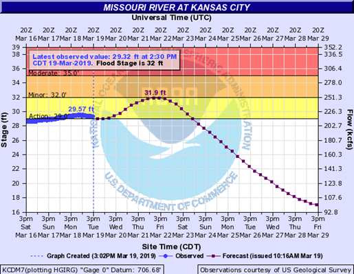 Figure 2 – National Weather Service Gage Information for the Missouri River at Kansas City.
If you do not want to type that in, just do a Google search for “Missouri river gage Kansas
City.”
Once at the website, you should find a graph that shows the past, present, and forecast stages for the Missouri River at Kansas City. Figure 2 shows an example of the information presented.
The forecast is only a prediction and is subject to change. The information is updated daily.
If the river exceeds flood stage, will I be flooded?
Not typically. You would only be flooded in the unlikely event of a levee breach. The purpose of the levee is to prevent flooding of low-lying areas when the river comes up.
The levee starts to do its job when the river exceeds the flood stage. It is not uncommon for the river to exceed flood stage. In recent history, the flood stage was exceeded in 1993
when the river crested at 48.8 feet, and in 1995, 1999, 2007, 2011, 2016, and 2019.
Can I experience other types of flooding at my property?
Yes. The protected area is low-lying and very flat. Intense rainfall events in North Kansas City can cause shallow flooding within the interior of the levee.
This flooding can occur when the capacity of the storm sewer system is exceeded. The levee does not protect from this type of flooding.
What is meant by the term “Flood Stage”?
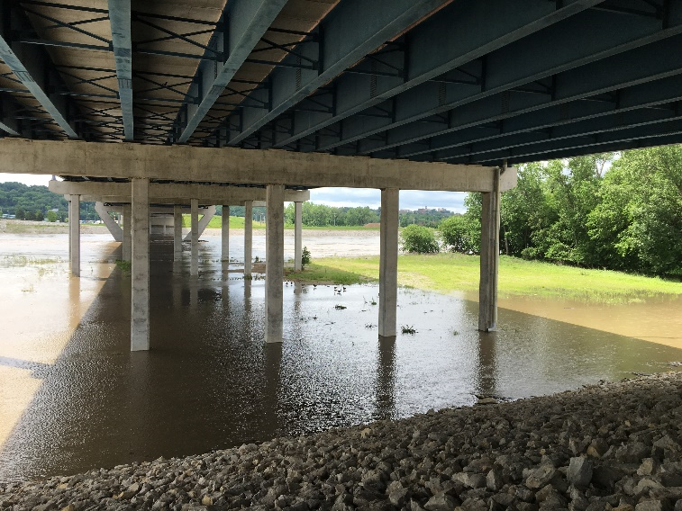 Figure 3 - Missouri River near Flood Stage at the I-35 bridge in North Kansas City.
A river reaches its flood stage when the flow first leaves the main channel and starts to flow in the floodplain. For the Kansas City reach, a river stage of 32 feet is considered the flood stage.
The flow depth is measured by a gage mounted on the Hannibal River Bridge. Figure 3 shows the river near flood stage at the I-35 bridge in North Kansas City. The water has left the main channel,
and there is shallow flooding between the river and the levee.
What is my risk from flooding?
The North Kansas City Levee District does not assess risk for properties within the protected area. Our single responsibility is to operate and maintain the system.
You must assess your own risk of living, working, or owning property within the area protected by the North Kansas City Levee Unit. The levee system was designed to
pass the 0.2 percent annual chance of occurrence (500-year) flood event in the Missouri River, and the District strives to maintain the system to the highest standards.
The levee system has historically performed with satisfaction under several large flood events, including the 1951 and 1993 Floods. During all flood events since its
construction in 1950, there has never been a failure or an evacuation resulting from a flood.
Should I purchase flood insurance for my property?
Those within the protected area should understand that the levee system reduces the risk of flooding but does not eliminate it.
For this reason, the North Kansas City Levee District encourages property owners within the protected area to purchase flood insurance.
While the purchase of flood insurance is encouraged, the North Kansas City Levee District does not mandate it.
I see on the news that there is a lot of flooding happening north of Kansas City. Should I be worried?
Flooding in the northern portions of the Missouri River Basin is always of concern, but these events do not always result in flooding in Kansas City.
If you live, work or own property within the area protected by the levee, you are provided a certain level of protection from flooding. We recommend that you
monitor the forecast for the Missouri River at Kansas City gage and pay attention to local conditions.
Why is it flooding in St. Joseph but not here in Kansas City?
Levee systems north of Kansas City are designed for a Missouri River flood. The North Kansas City Levee Unit is designed to withstand simultaneous
flooding from both the Missouri and Kansas Rivers. When only one of the two river systems floods, we experience only mild to moderate flooding.
Can I drive on the levee to see what is going on?
We prefer that you did not. That is why there is a fence. The levee is patrolled during times of flooding, and we cannot allow unauthorized access to the public.
Does the North Kansas City Levee District have a plan of action during a floods?
Yes. There is a very detailed Emergency Action Plan that we follow developed by the U.S. Army Corps of Engineers. Since the 1993 Flood, the plan has been regularly
updated and improved. The monitoring efforts and actions that need to be taken increase as the river stages rise. Until river stages reach 37 feet, our efforts are
only to monitor the condition of the levee.
When should I evacuate?
We understand that if you live, work, or own property behind the levee, times of flooding can be stressful. The North Kansas City Levee District will call for
a mandatory evacuation when there is either an imminent chance of failure or when the river is forecasted to exceed a stage of 48.8 feet. If a flood is severe
enough but does not meet the mandatory evacuation requirements, a call for voluntary evacuation could be issued as a precaution. The decision for evacuation lies
with the Emergency Management Directors for the cities of North Kansas City and Kansas City, Missouri.
How do I know that the levee system is safe and reliable?
No levee system can completely eliminate the risk of flooding. There is always a chance that something can go wrong. However, the North Kansas City Levee District
takes great effort to operate and maintain the levee system to the standards prescribed by the USACE and the Federal Emergency Management Agency (FEMA). Our efforts
include the following:
- We collect sufficient money from the property owners to properly operate, maintain and improve the system. If you are a property owner, you help keep the levee system reliable.
- We review plans for work near the levee system for compliance with USACE guidelines.
- We conduct quarterly inspections of the levee system to assess maintenance deficiencies.
- We correct maintenance deficiencies promptly.
- We keep the levee mowed, free of trees, and free of burrowing animals.
- We conduct regular training for Flood Fight activities in cooperation with the City.
- We plan, budget, and implement routine maintenance following our Operations and Maintenance Manual.
- The USACE conducts an annual, routine inspection to identify maintenance concerns.
- The USACE conducts detailed, periodic inspections approximately every 5 years.
What does the North Kansas City Levee District see as the greatest risk?
The USACE evaluates the risk and reliability of all flood control systems under its supervision. Most of the risk drivers identified for the North Kansas City Levee Unit have been addressed
with capital improvement projects in recent years. There is one outstanding issue with the evacuation plan for the protected area. While each City within the protected area has a general
evacuation plan in place, the USACE has noted that these plans are not specific to an evacuation associated with a levee breach. The North Kansas City Levee District is currently working
with the City of North Kansas City to refine its evacuation plan to resolve this issue.
The USACE has become more diligent in its oversight of levee systems over the past decade. The District has also changed the way it manages the system. Operation and maintenance efforts are
proactive and prompt. The District is hesitant to increase its benefit assessments but understands that gradual adjustments must be made to meet the ever-increasing standards. Fortunately,
the federal government is funding more projects to improve levee systems. Both the Harlem and National Starch Underseepage Projects were completed in 2013 with federal funding assistance.
With these additions, the system is likely more reliable today than when it was first constructed.
How are Board Members Elected?
Board Members are elected for a term of 5 years by the property owners within the protected area. Elections are held every February at the annual Land Owner's Meeting.
Who pays for the operation and maintenance of the Levee District?
Property owners within the protected area of the levee are charged a yearly amount. A property's contribution is based on an assessment made by the courts.
What is the relationship between the Levee District and the U.S. Army Corps of Engineers?
While considered a federal levee, the system is owned and operated by the North Kansas City Levee District. The USACE only provides technical guidance and oversight.
The Levee District is responsible for operating and maintaining the system in accordance with USACE standards.
Why must I submit plans and specifications for review when working near the levee?
The Levee District is not a codes enforcement agency. We ask to review plans and specifications for work within the "critical zone" of the levee because of the unique
conditions that occur when the river floods. We review plans to ensure that the materials used and construction practices used are not detrimental to the levee's integrity.
Our review also determines whether or not the new construction conforms to the guidelines prescribed by the USACE.
What is the “Critical Zone” of the levee?
During a flood event, the water in the river is higher than the ground behind the levee. The water tries to equalize by flowing through the sands beneath the levee
and into the protected area. If this pressurized groundwater finds an open path, it has the potential to erode the levee foundation and cause damage. The critical zone
is an area along the levee where the influences of this pressurize groundwater is the greatest. It is generally defined as 300 feet riverward and 500 to 1000 feet landward the levee.